Wednesday, 11 October 2017

The Diomede Islands: The Town Where You Can Gaze Into Tomorrow

Situated in the Bering strait, the body of water which separates Russia from the USA, are the two Diomede Islands. The larger of the islands, aptly named Big Diomede, is owned by Russia. Just 3.8 kilometers East is the smaller island, Little Diomede, part of the US State of Alaska. These islands are thought to be the last remnants of a land bridge, which connected the continent of Asia to North America during the last Ice Age.

https://www.maritimeprofessional.com/blogs/post/diomede-islands-13618

The International Date Line (IDL) is an arbitrary line which runs from North to South around the 180th Meridian, which demarcates the end of one day and the beginning of the next. As time zones are defined locally by individual nations, the IDL swerves around territorial boundaries. Rather interestingly, therefore, the IDL passes between the two Diomede Islands. Meaning at a given time, Little Diomede is a calendar day behind Big Diomede. By standing on one of the islands, you can effectively look either into the future or into the past*. 

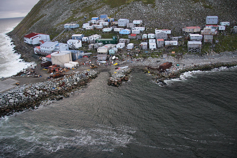
The islands are not uninhabited either. The island of Little Diomede is home to a small Inupiat village called Inalik (below), which has a population of 115. In Winter, the waters between the islands freeze, allowing people to cross between the islands- effectively becoming a land border between the USA and Russia. During the Cold War, such crossings were no longer permitted, and the border between the Diomede islands was known as the 'Ice Curtain'. Although now more relaxed, border restrictions between the two countries prevent the native population from reuniting with their relatives in Russia.


https://commons.wikimedia.org/wiki/File:Little_Diomede_Island_village.jpeg

*Due to locally defined time zones, the two islands are 21 hours apart, rather than a whole day. So if you were hoping to 'look into the future' on Little Diomede, you should do it after 03:00.


Sunday, 8 October 2017

Islands And Lakes: Well Isle Be Damned...

The largest island in the world, at 2,166,086 square kilometers (8.9 times larger than the UK), is Greenland. Below is a size comparison of Greenland with the contiguous United States. Despite this, Greenland has a population of just over 56,000, making it one of the most sparsely populated areas on Earth. The largest lake is the Caspian Sea, at 371,000 square kilometers, in Central Asia. But of course, you may have learnt this already back in Geography class- and that isn't the point of this blog!


http://www.mylifeelsewhere.com/country-size-comparison/united-states/greenland

Islands within lakes can themselves be an important geographical feature. Grand Isle County, Vermont, is an entire county in the US comprising of lake islands within Lake Champlain. So what is the largest lake island in the world? Manatoulin island (below left), a Canadian island situated in lake Huron, is the largest. At 2766 square kilometers, it is larger than the nation of Luxembourg. The second largest lake island is RenĂ©-Levasseur island in the Canadian province of Quebec. This circular island (below right), is intriguing for a number of reasons. Firstly, the island and its annular lake, the Manicouagan reservoir, are situated in the crater of one of the largest known prehistoric meteor strikes. Secondly, it is actually an artificial island, created from flooding two existing lakes in 1970. At 2020 square kilometers, it is the largest artificial island in the world. Finally, RenĂ©-Levasseur is a rare example of an island which is larger than the lake in which it is situated. 

https://commons.wikimedia.org/wiki/File:Manitoulin_Island.jpg
https://commons.wikimedia.org/wiki/File:Manicouagan-EO.JPG

We can go further, and talk about the largest lakes on islands, and lake islands within them, and lakes on those lake islands. However, I think this would be dull and repetitive. Instead, I've summarised the largest of these various configurations of lakes and islands in the diagram below:


If you really want a headache, think about the island in a lake, on an island in a lake, on an island; a 'third order island'. The largest of these was discovered in 2012 by famous game show contestant and author, Ken Jennings, who spotted it after spending hours scanning Google Earth. The 4 kilometer squared island is located on Victoria Island, Canada and is as yet unnamed and uninhabited. It is highly probable that humans have never even set foot on this unusual piece of land.

https://earthobservatory.nasa.gov/IOTD/view.php?id=85342

I hope you enjoyed the post. If you want to read more, click 'Follow' on the homepage.

Saturday, 7 October 2017

International Waters: What Makes The 'Peanut Hole' So Salty?


A country with a coastline can exert legal influence on some of the waters that surround it. Internationally agreed maritime laws allow countries to have complete jurisdiction over waters within 12 nautical miles of their coast (territorial waters), and a few more limited rights over waters within 200 nautical miles; the Exclusive Economic Zone (EEZ). Boats of any country can come and go here, but countries can set laws that prevent economic hindrance to their territory, such as the right for international vessels to fish. Beyond this, international waters persist, which are not under the jurisdiction of any country. International waters, or the high seas, are denoted in dark blue on the map below:

https://commons.wikimedia.org/wiki/File:International_waters.svg


As you can imagine, disputes over territorial waters and EEZ can get very complicated, depending on who has jurisdiction over a piece of coast, or even whether an island truly counts as an island. The complexity of a country's maritime jurisdiction only increases if a country is very large, or has many islands.

Russia, being the largest country in the world, and having one of the largest coastlines, is no exception to this. An example of where rules over international waters can get quite sticky is in the Sea of Okhotsk. The sea is surrounded mainly by Russia, and so Russia's EEZ extends 200 nautical miles inwards. This covers almost the entire body of water, except a strip of water in the centre, which measures 35 x 300 miles. This is known colloquially as the 'Peanut Hole'. It is shown below, on a close-up of the Sea of Okhotsk:

https://commons.wikimedia.org/wiki/File:Peanut_Hole.jpg

As previously mentioned, boats can enter the EEZ freely, however a country can set down laws such as prohibiting fishing by foreign vessels. Prior to 2014, Russia had no such jurisdiction over the 'Peanut Hole'. the result was some countries- notably Japan, China, South Korea and Poland- entering the region and fishing. This caused quite a headache for Russia, who feared their straddling fish stock, such as Pollock, could be affected. 

Russia ended up petitioning the UN who, in 2014 agreed, and determined the 'Peanut Hole' to be part of a continental shelf that belonged to Russia, and gave them rights to set laws that govern international fishing rights. 

I hope you enjoyed the post. If you want to read more, click 'Follow' on the homepage.

The Mid-Atlantic Ridge (Part 1): The Powerhouse of Earth

This blog post will focus on some of the features of a little known geological treasure of Earth; the Mid-Atlantic Ridge. This ridge is a di...